8 April 2013
Kenya's Maasai keep lions at bay with solar power and ingenuity
Teenage Maasai cattle herder invents illuminated fence to prevent lions from preying on his father's livestock
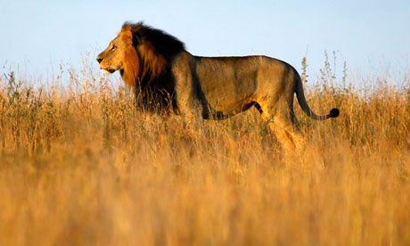
Fenced out … A teenage Maasai cattle herder has invented an illuminated fence to keep lions from Nairobi national park at bay. Photograph: Marko Djurica/Reuters
When it came to keeping hungry lions at bay, an old-fashioned scarecrow just wasn't up to the job. So Richard Turere, a 13-year-old Maasai cattle herder, combined rudimentary technology with teenage ingenuity to find another way.
Turere is the inventor of "lion lights", a fence made of a car battery, solar panel and torch bulbs that ensures lions no longer dare touch his father's livestock. The young Kenyan has been lauded as an inspiration after giving a recent TED talk about his invention.
Turere lives in Kitengela on the edge of Nairobi national park. He told how wild animals that migrate from the park are pursued and killed by lions.
"My community, the Maasai, we believe that we came from heaven with all our animals and all the land for herding them, and that's why we value them so much," says Turere, who started herding his family's cattle when he was nine. "So I grew up hating lions so much. The morans are the warriors who protect our community and the livestock, and they're also upset about this problem. So they kill the lions … And I think this is why the Nairobi national park lions are few."
Turere said he tried various ideas for a more peaceful solution, such as a kerosene lamp and a scarecrow. "But lions are very clever. They will come the first day and they see the scarecrow, and they go back, but the second day, they'll come and they say, this thing is not moving here, it's always here. So he jumps in and kills the animals."
28 March 2013
UGA discovery may allow scientists to make fuel from CO2 in the atmosphere

Athens, Ga. - Excess carbon dioxide in the Earth's atmosphere created by the widespread burning of fossil fuels is the major driving force of global climate change, and researchers the world over are looking for new ways to generate power that leaves a smaller carbon footprint.
Now, researchers at the University of Georgia have found a way to transform the carbon dioxide trapped in the atmosphere into useful industrial products. Their discovery may soon lead to the creation of biofuels made directly from the carbon dioxide in the air that is responsible for trapping the sun's rays and raising global temperatures.
"Basically, what we have done is create a microorganism that does with carbon dioxide exactly what plants do-absorb it and generate something useful," said Michael Adams, member of UGA's Bioenergy Systems Research Institute, Georgia Power professor of biotechnology and Distinguished Research Professor of biochemistry and molecular biology in the Franklin College of Arts and Sciences.
During the process of photosynthesis, plants use sunlight to transform water and carbon dioxide into sugars that the plants use for energy, much like humans burn calories from food.
25 March 2013
Climate change will bring greater extremes in weather, warns Government's chief scientific adviser
Climate change will bring greater extremes in weather, the Government's outgoing chief scientific adviser has warned as he called for urgent action to tackle global warming.
Professor Sir John Beddington said the effects of climate change on the weather were already being felt in the UK.
"In a sense we have moved from the idea of global warming to the idea of climate change, and that is rather important - yes, indeed, temperatures are increasing but the thing that is going to happen is that we are going to see much more variability in our weather," he told BBC Breakfast.
"I think you only have to look at the last few years to see how that is actually starting to manifest itself even in the UK."
Sir John said there were "massive problems" in the world of food, water and energy security as the global population increases, all of which would be exacerbated by climate change.
Even if effective action was taken now on global warming, he said there would be "significant" climate change over the next 20 to 25 years as results of past global emissions.
"We have massive problems in the world - in 12 years' time there will be another billion people on the planet and we have big issues of food security, water security and energy security and many, many people will start to be living in cities," he said.
Dead forests release less carbon into atmosphere than expected

Vast swaths of forest are succumbing to pine beetle outbreaks. Credit: David Moore/UA School of Natural Resources and the Environment (Phys.org) —Billions of trees killed in the wake of mountain pine beetle infestations, ranging from Mexico to Alaska, have not resulted in a large spike in carbon dioxide released into the atmosphere, contrary to predictions, a UA-led study has found. Ads by Google Top Human Resource Job - Find the latest Human Resource Job in Europe. Join Experteer® today! - Experteer.com/Human+Resource+Job Massive tree die-offs release less carbon into the atmosphere than previously thought, new research led by the University of Arizona suggests. Across the world, trees are dying in increasing numbers, most likely in the wake of a climate changing toward drier and warmer conditions, scientists suspect. In western North America, outbreaks of mountain pine beetles (Dendroctonus ponderosae) have killed billions of trees from Mexico to Alaska over the last decade. Given that large forested areas play crucial roles in taking carbon dioxide out of the atmosphere through photosynthesis and turning it into biomass, an important question is what happens to that stored carbon when large numbers of trees die.
Read more at: http://phys.org/news/2013-03-dead-forests-carbon-atmosphere.html#jCp
8 March 2013
Large rise in CO2 emissions sounds climate change alarm
Hopes for 'safe' temperature increase within 2C fade as Hawaii station documents second-greatest emissions increase
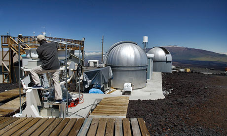
Hawaii's Mauna Loa observatory, where record CO2 increases are being documented (Photograph: Richard Vogel/AP)
The chances of the world holding temperature rises to 2C – the level of global warming considered "safe" by scientists – appear to be fading fast with US scientists reporting the second-greatest annual rise in CO2 emissions in 2012.
Carbon dioxide levels measured at at Mauna Loa observatory in Hawaii jumped by 2.67 parts per million (ppm) in 2012 to 395ppm, said Pieter Tans, who leads the greenhouse gas measurement team for the US National Oceanic and Atmospheric Administration (NOAA). The record was an increase of 2.93ppm in 1998.
The jump comes as a study published in Science on Thursday looking at global surface temperatures for the past 1,500 years warned that "recent warming is unprecedented", prompting UN climate chief, Christiana Figueres, to say that "staggering global temps show urgent need to act. Rapid climate change must be countered with accelerated action."
Tans told the Associated Press the major factor was an increase in fossil fuel use. "It's just a testament to human influence being dominant", he said. "The prospects of keeping climate change below that [two-degree goal] are fading away."
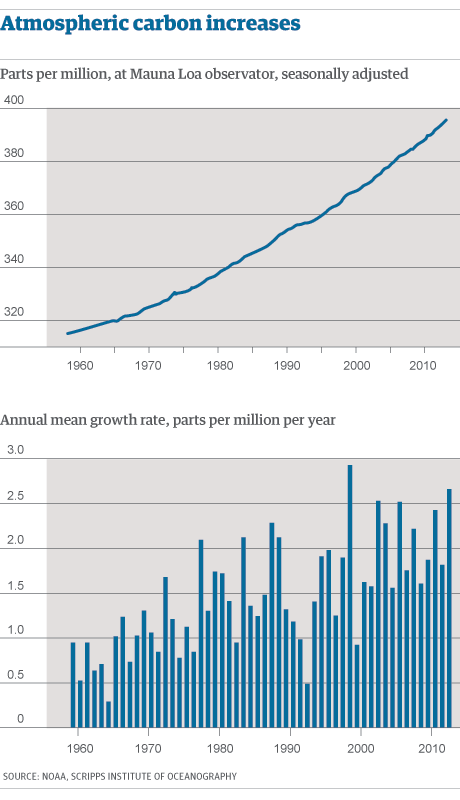 Preliminary data for February 2013 show CO2 levels last month standing at their highest ever recorded at Manua Loa, a remote volcano in the Pacific. Last month they reached a record 396.80ppm with a jump of 3.26ppm parts per million between February 2012 and 2013.
http://www.guardian.co.uk/environment/2013/mar/08/hawaii-climate-change-second-greatest-annual-rise-emissions
26 February 2013
Rising Sea Levels Could Spark Largest Migration of Displaced People in History
The Hungry Tide
This Saturday March 2 is the Warrior Day of Action when Pacific Islanders on the frontline of climate change
will mobilize to send a message to the world that they will fight to
protect their land, their existence and their identity from rising
tides.
To support their efforts for climate justice, Specialty Studios is offering the award-winning film The Hungry Tide
free for viewing and sharing through March 3. The Australian-produced
53-minute documentary personalizes the plight of the Pacific island
nation of Kiribati, which is already being inundated by rising seas and
could become the world’s first climate-induced migration of an entire
nation.
21 February 2013
In Rich and Poor Nations, Giving Makes People Feel Better Than Getting, Research Finds
Feeling good about spending money on someone else rather than for personal benefit may be a universal response among people in both impoverished countries and rich nations, according to new research published by the American Psychological Association.
"Our findings suggest that the psychological reward experienced from helping others may be deeply ingrained in human nature, emerging in diverse cultural and economic contexts," said lead author Lara Aknin, PhD, of Simon Fraser University in Canada.
http://www.sciencedaily.com/releases/2013/02/130221104357.htm
19 February 2013
E.ON lobbied for stiff sentences against Kingsnorth activists, papers show
Power giant warned then energy secretary Ed Miliband that failure to impose tough sentences would 'impact' investment
James Ball

Kingsnorth protest: police arrest an environmental campaigner. Photograph: Leon Neal/AFP/Getty Images
The UK chief executive of energy giant E.ON repeatedly lobbied the then-energy secretary Ed Miliband and others over the sentencing of activists disrupting the company's power plants, warning that any failure to issue "dissuasive" sentences could "impact" upon investment decisions in the UK.
The warnings, which came while the government was still trying to persuade E.ON and others to invest in next-generation nuclear plants, have been described by activists as "wholly improper".
Dr Paul Golby, who was chairman and CEO of E.ON UK until December 2011, met with Miliband in February 2010 to discuss concerns around lax sentencing of eco-activists, following, in particular, the release of six campaigners engaged in direct action at Kingsnorth, a coal-powered station owned by E.ON.
A briefing document prepared for the Department of Energy and Climate Change's (DECC) permanent secretary in January 2011 by civil servants, ahead of a further meeting with Golby, cautioned that the issue of activists' sentences had been raised on several previous occasions.
Referring to a group of activists due to be sentenced for aggravated trespass at Ratcliffe, another power station owned by E.ON, on the same day as Golby's scheduled meeting, the memo cautioned: "Today [5th Jan] these 20 activists are due to be sentenced. EoN, and indeed other market participants in the generating sector, are hoping for a dissuasive sentencing to discourage similar such incidents in the future."
The Ratcliffe protest was later revealed as one of the protests infiltrated by undercover policeman Mark Kennedy, one of those at the centre of a row on the limits of undercover policing, following revelations thast police officers had relationships, and even fathered children, with activsts.
The memo went on to note that following the release of the Kingsnorth protestors, Golby had written to the department to "express his concern and highlight the impact upon the attractiveness of the UK's energy market for global investors".
5 February 2013
Leading paper firm pledges to halt Indonesian deforestation
Asia Pulp and Paper will end the clearing of forest across its supply chain by preserving high-carbon stock rainforests
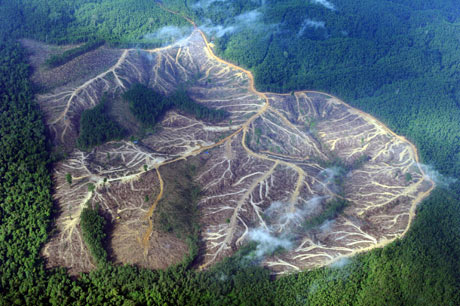
A Greenpeace aerial survey reveals one area of deforestation among hundreds of thousands of hectares in Sumatra. Photograph: AFP/Getty
The world's third biggest paper company has pledged to halt deforestation in Indonesia, and help to restore the habitats of the rare Sumatran tiger and orangutan, following a long-running campaign by environmentalists.
Asia Pulp and Paper (APP) said on Tuesday that it would end the "clearing of natural forest" across its entire supply chain, with immediate effect. From now on, it has pledged to work to preserve "high conservation value" and "high-carbon stock" forests.
The move marks a major victory for green campaigners, as paper made from the pulped remains of some of the last virgin rainforests of south-east Asia has been found in products across the world, and its manufacture has contributed to the endangerment of threatened wildlife.
Aida Greenbury, managing director for sustainability at APP, told the Guardian the company was keen to show an example to the rest of the industry. "It is time to stop talking and fighting – it is time for us to show real action on the ground. It is time to stop talking about climate change but address it."
After a long investigation by Greenpeace, APP was found last year to have used trees that are endangered and cannot legally be logged in Indonesia in packaging for major clients. The green group traced DNA from ramin trees – native to the same habitat as the rare Sumatran tiger – to packaging in consumer products.
Fiona Harvey, environment correspondenthttp://www.guardian.co.uk/environment/2013/feb/05/paper-firm-indonesian-deforestation?intcmp=122
4 February 2013
India's river-linking project mired in cost squabbles and politics
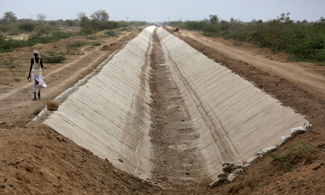
The idea of linking India's rivers to put an end to droughts and floods has exercised a mesmerising grip on the nation's mind for decades. That grip has become even stronger since neighbouring China embarked upon various water diversion projects, and pushed ahead with its own gargantuan engineering projects.
So it came as no surprise when in December 2012 India announced progress on plans to connect 37 rivers across the nation through 31 links with 9,000 km of canals, saying such a project was feasible. This exercise, the government estimates, would cost $140bn.
But even after China went ahead with its plan to construct more than half a dozen dams that India says would affect the flow of water downstream into its own territory, the plan to link Indian rivers by 2016 does not seem to be progressing easily, with both economists and environmentalists now believing the project is unfeasible.
The government's own estimates suggest that inflation and debt-servicing costs during the four-year period of construction would push costs even higher than the already-unaffordable $140bn estimate. The supreme court is also concerned over potential financial shortfalls.
Last February, the supreme court criticised the government and directed the authorities to implement the plan without any delay, calling it "a matter of national benefit and progress".
http://www.guardian.co.uk/environment/2013/feb/05/india-river-link-plan-progress-slow?intcmp=122
2 February 2013
California Irrigation Changing Weather Patterns in American Southwest
by

Water diverted to central California's farmlands boosts rainfall in nearby states and may even exacerbate periodic flooding in some regions, a new study suggests. The phenomenon may also be happening elsewhere in the world.
California's Central Valley—an area almost twice the size of Massachusetts where farmers raise more than 200 different crops, including apricots, asparagus, cotton, and grapes—is one of the largest irrigated regions in the world. Every year, several cubic kilometers of water are supplied to the Central Valley's fields, about 60% of it from river flow diverted into the region and the rest from wells. A significant amount of that liquid evaporates from fields rather than nourishing crops, says James Famiglietti, a hydrologist at the University of California (UC), Irvine. That boosts humidity in the valley, according to previous research, but scientists haven't evaluated its effects farther afield.
So Famiglietti and university colleague Min-Hui Lo employed a global climate model. In one set of the team's simulations, no irrigation occurred. In another set, the researchers added a volume of water equivalent to 350 millimeters of precipitation falling on each square kilometer of the valley's fields between May and October, the time of year when soil moisture typically takes a dive if irrigation isn't provided.
http://news.sciencemag.org/sciencenow/2013/02/california-irrigation-changing-w.html
1 February 2013
Increases in Extreme Rainfall Linked to Global Warming

A worldwide review of global rainfall data led by the University of Adelaide has found that the intensity of the most extreme rainfall events is increasing across the globe as temperatures rise.
In the most comprehensive review of changes to extreme rainfall ever undertaken, researchers evaluated the association between extreme rainfall and atmospheric temperatures at more than 8000 weather gauging stations around the world.
Lead author Dr Seth Westra said, "The results are that rainfall extremes are increasing on average globally. They show that there is a 7% increase in extreme rainfall intensity for every degree increase in global atmospheric temperature.
"Assuming an increase in global average temperature by 3 to 5 degrees Celsius by the end of the 21st century, this could mean very substantial increases in rainfall intensity as a result of climate change."
Dr Westra, a Senior Lecturer with the University of Adelaide's School of Civil, Environmental and Mining Engineering and member of the Environment Institute, said trends in rainfall extremes were examined over the period from 1900 to 2009 to determine whether they were becoming more intense or occurring more frequently.
http://www.sciencedaily.com/releases/2013/02/130201100036.htm
29 January 2013
World Bank spending on forests fails to curb poverty, auditors claim
Report by World Bank's own evaluators say its investments support logging and do little to help rural poor people
Foresters rest next to a trunk in Katwe, the Democratic Republic of the Congo, 2008. Photograph: Lionel Healing/AFP/Getty Images
The World Bank's $4.1bn (£2.6bn) investments in forestry over the past 10 years have done little to reduce poverty, improve conservation, tackle climate change or benefit local communities in developing countries, a study by its own inspectors has found.
The 202-page report – a copy of which has been seen by the Guardian – was compiled by the Independent Evaluation Group (IEG), which consists of senior bank staff and outside consultants. The document says the bank's financial support helped to protect 24m hectares (59m acres) of forest around the world and to classify 45m ha of forest as being on indigenous people's land. But it says the bank mostly failed to address critical social and environmental issues.
The World Bank funded 345 major forestry projects in 75 countries in the decade to July 2011. The IEG panel, which visited many of the projects and interviewed hundreds of people, criticised the bank strongly for:
• Continuing to support industrial logging.
• Not involving communities in decision-making.
• Assuming that benefits would accrue to the poor rather than the rich and powerful.
• Paying little attention to rural poverty.
The IEG report has been sent to the UK and other major contributors to bank funds, and is due to be discussed on 4 February. It is particularly embarrassing for Britain because the government has donated $600m since 2008 to the bank's forest investment programme, and the departments of energy and climate change, environment, and international development (DfID) have all claimed to be committed to fighting forest loss in developing countries. Last year, DfID said in response to a select committee inquiry into its funding of the World Bank that it "is one of the most effective uses of British aid" (pdf).
23 January 2013
Massive melting of Andes glaciers

The tropical glaciers are melting at their fastest rate in 300 years
Glaciers in the tropical Andes have shrunk by 30-50% since the 1970s, according to a study.
The glaciers, which provide fresh water for tens of millions
in South America, are retreating at their fastest rate in the past 300
years.
The study included data on about half of all Andean glaciers
and blamed the melting on an average temperature rise of 0.7C from
1950-1994.
Details appear in the academic journal Cryosphere.
The authors report that glaciers are retreating everywhere in
the tropical Andes, but the melting is more pronounced for small
glaciers at low altitudes.
Glaciers at altitudes below 5,400m have lost about 1.35m in
ice thickness per year since the late 1970s, twice the rate of the
larger, high-altitude glaciers.
"Because the maximum thickness of these small, low-altitude
glaciers rarely exceeds 40 metres, with such an annual loss they will
probably completely disappear within the coming decades," said lead
author Antoine Rabatel, from the Laboratory for Glaciology and
Environmental Geophysics in Grenoble, France.
China and Australia top list of 'carbon bomb' projects Greenpeace analysis shows 14 planned giant fossil fuel projects will increase global emissions by 20%
22 JanuaryThe Shengli opencast coal mine in Xilin Hot, Inner Mongolia. China's five north-western provinces aim to increase coal production by 620m tonnes by 2015. Photograph: Lu Guang/Greenpeace China and Australia top a global list of planned oil, gas and coal projects that will act as "carbon bombs" and push the planet towards catastrophic climate change, a Greenpeace report warned on Tuesday. The Point of No Return study, by consultancy firm Ecofys for Greenpeace, calculated that the 14 giant fossil fuel projects would produce 6.3 gigatonnes of CO2 a year in 2020 – as much as the entire United States emits annually. The largest contributors will be China's five north-western provinces, which aim to increase coal production by 620m tonnes by 2015, generating an additional 1.4bn tonnes of greenhouse gases a year. Australia's burgeoning coal export industry, already the largest in the world, is in second place due to its potential growth to 408m tonnes of shipped resource a year by 2025, resulting in an annual 760m tonnes of CO2. Meanwhile, controversial exploitation of oil and gas reserves in the Arctic could release 520m tonnes of CO2 a year, with further major emissions set to flow from other new fossil fuel frontiers, such as tar sands oil in Canada and shale gas in the US.
21 January 2013
January 20, 2013
It is a much debated question: why did Central African forests become partially fragmented between 2,500 and 2,000 years ago, leaving room for more open forest landscapes and savannah?
Recently, a publication attempted to explain that it was the farming Bantu peoples who were responsible for this, through the large-scale clearing that they undertook. But IRD (Institut de recherche pour le développement) experts and their partners (1) have contested this argument in a recent article in the journal Science.
The fragmentation of the Central African forest was they claim, a result of drastic climate change. In fact, during this period a general desiccation in the climate spread from the equatorial region right to the edges of the Sahel. Numerous data-sets show conclusively that it was only 500 years later, (2,000 years ago), that Bantu colonisation became widespread.
The first Bantu populations merely therefore took advantage of the thinning forest to enter these areas, clear fields and begin growing their crops.
AFearsome Foursome of Eruptions Seen from Space
When the major fragmentation of forests started 2,500 years ago, the Bantu had only just learnt to use iron.
A boom period for the Bantu
The concentration and spreading of archaeological records – more than 500 radiocarbon dates established on pottery, stone or iron tools – show that the massive colonisation of the Congo Basin by Bantu farmers started only 2,000 years ago, and that it reached a peak between 1,900 and 1,600 years ago. At the same time, all the available paleo-environmental data indicate a new phase of forest expansion that also started about 2,000 years ago depending on the regions, proving that growing Bantu settlement did not prevent the vegetation from flourishing. The cultures simply took advantage from the opening up of the forest to enter it more easily.
http://www.pasthorizonspr.com/index.php/archives/01/2013/the-deforestion-of-central-africa-man-or-climate
 |
| Shiveluch volcano erupts on Jan. 11, 2013. CREDIT: NASA Earth Observatory |
With more than 300 volcanoes crowded into a finger of land roughly the size of California, Russia's Kamchatka peninsula is home to the world's highest concentration of active volcanoes.
Only 29 volcanoes are active, occasionally spilling lava down their slopes or shooting steam and ash into the sky. On Jan. 11, NASA's Terra satellite snapped a picture of a fearsome foursome, as a quartet of Kamchatka's volcanoes erupted at the same time.
The four volcanoes — Shiveluch, Bezymianny, Tolbachik and Kizimen — are separated by only 110 miles (180 kilometers), according to NASA's Earth Observatory.
January 20, 2013
THE DEFORESTATION OF CENTRAL AFRICA: MAN OR CLIMATE?
It is a much debated question: why did Central African forests become partially fragmented between 2,500 and 2,000 years ago, leaving room for more open forest landscapes and savannah?
Recently, a publication attempted to explain that it was the farming Bantu peoples who were responsible for this, through the large-scale clearing that they undertook. But IRD (Institut de recherche pour le développement) experts and their partners (1) have contested this argument in a recent article in the journal Science.
The fragmentation of the Central African forest was they claim, a result of drastic climate change. In fact, during this period a general desiccation in the climate spread from the equatorial region right to the edges of the Sahel. Numerous data-sets show conclusively that it was only 500 years later, (2,000 years ago), that Bantu colonisation became widespread.
The first Bantu populations merely therefore took advantage of the thinning forest to enter these areas, clear fields and begin growing their crops.
AFearsome Foursome of Eruptions Seen from Space
When the major fragmentation of forests started 2,500 years ago, the Bantu had only just learnt to use iron.
A boom period for the Bantu
The concentration and spreading of archaeological records – more than 500 radiocarbon dates established on pottery, stone or iron tools – show that the massive colonisation of the Congo Basin by Bantu farmers started only 2,000 years ago, and that it reached a peak between 1,900 and 1,600 years ago. At the same time, all the available paleo-environmental data indicate a new phase of forest expansion that also started about 2,000 years ago depending on the regions, proving that growing Bantu settlement did not prevent the vegetation from flourishing. The cultures simply took advantage from the opening up of the forest to enter it more easily.
http://www.pasthorizonspr.com/index.php/archives/01/2013/the-deforestion-of-central-africa-man-or-climate
January 17, 2013
Study Finds Severe Climate Jeopardizing Amazon Forest
 At left, the extent of
the 2005 megadrought in the western Amazon rainforests during the summer
months of June, July and August as measured by NASA satellites. The
most impacted areas are shown in shades of red and yellow. The circled
area in the right panel shows the extent of the forests that experienced
slow recovery from the 2005 drought, with areas in red and yellow
shades experiencing the slowest recovery.
At left, the extent of
the 2005 megadrought in the western Amazon rainforests during the summer
months of June, July and August as measured by NASA satellites. The
most impacted areas are shown in shades of red and yellow. The circled
area in the right panel shows the extent of the forests that experienced
slow recovery from the 2005 drought, with areas in red and yellow
shades experiencing the slowest recovery.
PASADENA, Calif. - An area of the Amazon rainforest twice the size of
California continues to suffer from the effects of a megadrought that
began in 2005, finds a new NASA-led study. These results, together with
observed recurrences of droughts every few years and associated damage
to the forests in southern and western Amazonia in the past decade,
suggest these rainforests may be showing the first signs of potential
large-scale degradation due to climate change.
An international research team led by Sassan Saatchi of NASA's Jet
Propulsion Laboratory, Pasadena, Calif., analyzed more than a decade of
satellite microwave radar data collected between 2000 and 2009 over
Amazonia. The observations included measurements of rainfall from NASA's
Tropical Rainfall Measuring Mission and measurements of the moisture
content and structure of the forest canopy (top layer) from the Seawinds
scatterometer on NASA's QuikScat spacecraft.
The scientists found that during the summer of 2005, more than 270,000
square miles (700,000 square kilometers, or 70 million hectares) of
pristine, old-growth forest in southwestern Amazonia experienced an
extensive, severe drought. This megadrought caused widespread changes to
the forest canopy that were detectable by satellite. The changes
suggest dieback of branches and tree falls, especially among the older,
larger, more vulnerable canopy trees that blanket the forest.
While rainfall levels gradually recovered in subsequent years, the
damage to the forest canopy persisted all the way to the next major
drought, which began in 2010. About half the forest affected by the 2005
drought - an area the size of California - did not recover by the time
QuikScat stopped gathering global data in November 2009 and before the
start of a more extensive drought in 2010.
16 January 2013

The wild columbine, among other plants, now flowers nearly a month earlier than it did in the 1800s. Image via Wikimedia Commons
Compared to extreme drought, blistering heat, massive wildfires and tropical cyclones, the latest indicator of climate change is unexpectedly attractive: early spring flowers. According to a study published today in the journal PLOS ONE, unusually warm spring weather in 2010 and 2012 at a pair of notable sites in the eastern U.S. led to the earliest spring flowering times on record—earlier than any other time in the last 161 years.
The researchers involved, from Boston University, the University of Wisconsin and Harvard, examined the flowers at two sites well-known for their roles in the early environmental movement: Walden Pond, where Henry David Thoreau started keeping flowering records back in 1852, and Dane County, Wisc., where Aldo Leopold first recorded flowering data in 1935.
“We were amazed that wildflowers in Concord flowered almost a month earlier in 2012 than they did in Thoreau’s time or any other recent year, and it turns out the same phenomenon was happening in Wisconsin where Aldo Leopold was recording flowering times,” lead author Elizabeth Ellwood of Boston University said in astatement. “Our data shows that plants keep shifting their flowering times ever earlier as the climate continues to warm.”
In Massachusetts, the team studied 32 native spring flowering plant species—such as wild columbine, marsh marigold and pink lady slipper—for which average flowering dates had been fairly well-documented between Thoreau’s time and our own. They found that the plants’ flowering dates had steadily moved earlier as temperatures increased—Thoreau saw them flower on May 15, while they flowered on April 25 and 24 in 2010 and 2012, respectively. In the two years studied, 27 of the 32 species had their earliest flowering date ever.
In Wisconsin, they examined 23 species with similarly thorough records and found even more dramatic shifts. Between the 1930s and the present day, the plants’ average flowering date moved from May 7 to April 13, and 19 of the 23 species studied set records in either 2010 or 2012. On the whole, the researchers found that the plants examined in both locations flowered 4.1 days earlier for every 1 degree Celsius increase in average spring temperature.
There’s little disagreement among scientists that climate change, as a whole, is a fearful proposition. But, interestingly, some botanists might actually see these findings as encouraging for the plants in particular. Those studied, at least, seem able to adapt to the warmer springs and shorter winters by flowering earlier, rather than missing out on crucial growing time—a flexibility that bodes well for their future in a warming climate.
Of course, this is only a stop-gap measure, as the scientists suspect that there is some flowering threshold the plants cannot pass. If winters get so short that these flowering plants have no time at all to go dormant, it would conceivably alter their annual growth cycle to an extent that threatens their survival—or allows plants from warmer areas to move in and outcompete the natives.
Posted By: Joseph Stromberg
16 January 2013
Heatwave suddenly shrinks seaweed's range

The seaweed provides habitat and food for other marine species (Source: Thomas Wernberg)
A recent marine heatwave off Western Australia rapidly shrank the distribution range of an ecologically-important seaweed by about 5 per cent, researchers report.
Scientists say the findings provide further evidence that extreme climate events can cause sudden "stepwise" changes to species distributions, on top of gradual changes brought by climate change.
Marine biologists Dr Dan Smale and Dr Thomas Wernberg, of the University of Western Australia, report on the changing distribution of the habitat-forming seaweed,Scytothalia dorycarpa, today in the Proceedings of the Royal Society B.
"The real benefit of this study is we've actually managed to quantify how much this species contracted its range in response to a single extreme climatic event," says Smale.
In early 2011 the temperate part of the Western Australian coastline experienced a record-breaking heatwave, which lasted for about several months.
In previous research, Smale, Wernberg and colleagues found the heatwave, which saw water temperatures climb to 2-4°C above normal for many weeks, had caused changes to the marine ecology at a couple of specific locations off the Western Australian coast.
Now they have taken a more detailed look at how the heatwave affected one particular ecologically-important seaweed species.
Seaweed studies
The seaweed Scytothalia dorycarpa normally grows in shallow waters from the temperate Western Australian and South Australian coasts, around to Tasmania.
Using surveys from hundreds of kilometres of coastline, carried out both before and after the heatwave, Smale and Wernberg were able to quantify the change in the seaweed's distribution in response.
"It seems to have contracted its range more than 100 kilometres pole-wards in response to this heatwave," says Smale. This is approximately 5 per cent of its total distribution.
The researchers also carried out other tests to confirm the heat was to blame for the contraction.
"Through standard lab experiments we showed that the seaweed cannot sustain physiological functions (e.g. photosynthesis) at the temperatures it experienced at the range edge during the heatwave," says Smale.
Permanent change
The researchers say that the contraction of range is likely to be permanent, since the main current the seaweed relies on for dispersal is pole-wards.
And since the seaweed provides a habitat and food source for so many other plants and animal the range contraction is likely to have far-reaching implications for the marine ecosystem, they say.
Biologist and ecologist Dr Amanda Bates, of the Institute for Marine and Antarctic Studies at the University of Tasmania, says research on the impact of climate change on species distribution has tended to focus on gradual changes.
For example, studies show the gradual movement of species up mountains coinciding with a warming in climate over 100 years, says Bates, who has been reviewing the literature in this area.
But, she says, Smale and Wernberg's research draws attention to the impact of extreme climatic events on ecosystem structure and species distribution.
"This is a really important layer when you're trying to predict how systems respond to climate change," says Bates, who has collaborated in the past with Smale and Wernberg.
"These extreme events might cause rapid stepwise range contractions that will exacerbate the gradual contraction that would be likely to occur with climate change."
15 January 2013
NASA: 2012 Was 9th Hottest Year on Record Worldwide

With the exception of 1998, the nine warmest years in the
132-year record all have occurred since 2000. Shown here, global
temperature anomalies (above or below the average) averaged from 2008
through 2012.
Last year was the ninth hottest year for the globe since 1880,
according to new data released by NASA and the National Oceanic and
Atmospheric Association (NOAA) today (Jan. 15).
Of the nine hottest years on record, eight have come since the year 2000, with 2005 and 2010 sharing the dubious title of hottest year on record. The new data reveal the alarming, long-term trend of global warming caused by human emissions of carbon dioxide and other greenhouse gases, climate scientists said.
"The planet is out of balance, there's more energy coming in than going out," said James Hansen, director of NASA's Goddard Institute for Space Studies, during the press conference. "So therefore we can predict with confidence that the next decade is going to be warmer than the last one."
While the planet overall experienced a warm year, the continental United States faced a particularly hot year that blew all previous records away. The average temperature, about 55.3 degrees Fahrenheit (12.9 Celsius) was 3.25 degrees Fahrenheight (1.8 degrees Celsius) higher than the average from 1951 to 1980. [The 7 Hottest Climate Change Stories of 2012]
"We've broken the record by more than one degree, that is quite impressive," said Thomas R. Karl, director, NOAA's National Climatic Data Center, Asheville, N.C., during a press briefing today. "It literally smashed the record."
The incredibly warm spring and summer in the United States led to early greening of vegetation, followed by extreme drought conditions that are still going on, Karl said in the press conference.
The findings emphasize that skyrocketing emissions of greenhouse gases such as carbon dioxide and methane are warming the planet. These gases trap heat in the atmosphere rather than letting it escape back into space.
The amount of carbon dioxide in the atmosphere has risen precipitously since the advent of the industrial revolution: In 1880, the atmospheric carbon dioxide concentration was about 285 parts per million, while today, it is more than 385 parts per million, according to NOAA's data. Though that carbon dioxide can come from natural sources, most of it comes from the burning of fossil fuels to power modern society.
Natural variations in weather mean the spike in atmospheric carbon dioxide may not translate into a year-over-year, consistent increase in the planet's temperature, but each successive decade will probably be warmer.
But one trend that will most probably occur next year is 2012's stunning loss of sea ice in the Arctic this summer and fall, Karl said. That can have global implications because the Arctic can affect sea levels and weather patterns across the planet.
Follow LiveScience on Twitter @livescience. We're also on Facebook & Google+.
Monday 14 January 2013
Fear of 'catastrophic' sea-level rise as ice sheets melt faster than predicted

Glaciologists fear they may have seriously underestimated the
potential for melting ice sheets to contribute to catastrophic sea-level
rises in coming decades which could see increases of a metre or more by
2100.
The ice sheets of Greenland and Antarctica contain about 99.5 per cent of the Earth's glacier ice and could raise sea levels by 65 metres if they melted completely – although experts think this is highly unlikely in the foreseeable future. However, a survey of the world's top 26 glaciologists found most believe melting of the ice sheets could be more rapid and severe than previously estimated. They believe that melting of the ice sheets alone this century would be likely to raise the average global sea level by 29cm, the poll found, but there is a five per cent chance of it increasing even further by a catastrophic 84cm.
The ice sheets of Greenland and Antarctica contain about 99.5 per cent of the Earth's glacier ice and could raise sea levels by 65 metres if they melted completely – although experts think this is highly unlikely in the foreseeable future. However, a survey of the world's top 26 glaciologists found most believe melting of the ice sheets could be more rapid and severe than previously estimated. They believe that melting of the ice sheets alone this century would be likely to raise the average global sea level by 29cm, the poll found, but there is a five per cent chance of it increasing even further by a catastrophic 84cm.
http://www.independent.co.uk/environment/climate-change/fear-of-catastrophic-sealevel-rise-as-ice-sheets-melt-faster-than-predicted-8440277.html
10 January 2013
Mercury poisoning is a growing global menace we have to address
As the US knows to its cost, coal-fired power is a major cause of mercury pollution. The world needs a treaty tough on emissions

Minamata sufferer
Suemi Uemura, with benumbed legs stretched out, in her home in Izumi,
Japan. Minamata disease is caused by industrial mercury pollution.
Photograph: Katsumi Kasahara/AP
While global mercury emissions are on the rise, negotiators, unfortunately, appear to be leaning towards a treaty with soft measures unlikely to prevent continued catastrophic impacts from this deadly and debilitating poison. Ironically, signatories propose to ink their treaty in Minamata, Japan, a town that famously suffered widespread mercury poisoning.
Health experts first described mercury poisoning, then called "Minamata disease", in Minamata city, in Japan, in 1956. Mercury discharges from the Chisso chemical plant contaminated finfish and shellfish, devastating the community's human and animal population for decades. Many of the region's citizens died and tens of thousands of people suffered mercury-related illnesses.
http://www.guardian.co.uk/commentisfree/2013/jan/10/mercury-poisoning-global-menace-treaty
Zambia bans hunting of lions and leopards

There are thought to be no more than about 4,500 lions in Zambia
Zambia has banned the hunting of lions and leopards because of the rapid decline in its numbers of big cats.
Zambia's tourism minister said there was more value in
game-viewing tourism than blood sport, which brought in just $3m (£1.9m)
last year.Sylvia Masebo said the country did not have enough cats for hunting purposes.
"Tourists come to Zambia to see the lion and if we lose the lion we will be killing our tourism industry," she told Reuters.
While lions are found in all of Zambia's major parks, their numbers are limited.
There are thought to be no more than about 4,500 lions in the whole country, while the leopard population is unknown.
Neighbouring Botswana is banning all sport hunting from 2014, while Kenya halted hunting for sport decades ago.
http://www.bbc.co.uk/news/world-africa-20969868
Sea level rise could lead to a cooler, stormier world
</i>")
Ice thaws will bring short-lived cooling (Image: Jeremy Walker/naturepl.com)
A catastrophic rise in sea level
before the end of the century could have a hitherto-unforeseen side
effect. Melting icebergs might cool the seas around Greenland and
Antarctica so much that the average surface temperature of the entire
planet falls by a few degrees, according to unpublished work by climate
scientist James Hansen of NASA's Goddard Institute for Space Studies in New York City.
While it might sound welcome, the
temperature differences produced by the "iceberg cooling effect" could
lead to even more climate chaos in a world already devastated by extreme
weather. Winter storms, for instance, are powered by the temperature
differences between the poles and the equator, so there might be storms
of unprecedented ferocity.
And the temporary cooling would be
deceptive. Due to the greenhouse effect, the planet as a whole would
still be accumulating heat - it's just that vast amounts of heat would
be going into melting ice and warming water. "It's a redistribution of
heat energy," says Daniel Sigman of Princeton University, who studies the end of the last ice age and was not involved in Hansen's work.
8 January 2013
Oil sands' toxins 'accumulate in freshwater ecosystems'

Studies have shown that oil sands operations lead to pollutants being released into water systems
Toxic
pollutants released by oil sands mining operations are accumulating in
freshwater ecosystems, research by Canadian scientists suggests.
A study of sediment in nearby lakes showed the level of
pollutants, known as PAHs, had risen since the 1960s when oil sands
development began.
However, the researchers added that PAH concentrations were still lower than those found in urban lakes.
The findings appear in the Proceedings of the National Academy of Sciences.
06 January 2012
Predicting the next big flood

The question most
people have about the threat of stormy weather and more flooding is the
one the scientists find hardest to answer: how bad is it going to be?
The fact is that the science of understanding why rain falls,
and where and when, and how it then soaks into the ground or spills
into the streets, is extremely challenging.
And Britain, as an island nation, tucked between the Atlantic
Ocean and the continental mass of Europe, and caught in a tussle
between mild maritime air and icy blasts from the Arctic, has the least
predictable weather of all.
So, as the Met Office tells us what we guessed already - that
2012 was one of the top five wettest years on record - a huge effort is
under way to improve the forecasting.
This could make the difference between floodwaters that are contained and those that ruin homes and wreck lives.
One initiative is research that involves bands of scientists
braving the turbulence of flying through the heart of storms - the only
way to measure what is happening inside them. I reported on one of these missions last year.
Waterfall-Climbing Fish Use Same Mechanism to Climb Waterfalls and Eat Algae
Jan. 4, 2013 — Going against
the flow is always a challenge, but some waterfall-climbing fish have
adapted to their extreme lifestyle by using the same set of muscles for
both climbing and eating, according to research published January 4 in
the open access journal PLOS ONE by Richard Blob and colleagues from Clemson University.
Nanomaterial inspired by nature paves way for greener energy
Based on structures found in the natural world which occur within mitochondria and chloroplasts, nature's own "fuel cells" and "solar cells", the new nanostructure is formed of a network of tiny wires, millionths of a millimetre in size, and is created by growing the metal in a template made from a plant molecule. This creates a structure known as a "bicontinuous cubic phase".
http://www.reading.ac.uk/news-and-events/releases/PR480150.aspx

2012: the year Britain's weather turned dangerous
Record rainfall led to widespread flooding, killing nine people, ruining crops and costing the country billions

A park bench in in
Pangbourne, Berkshire. Flooding in 2012 cost nine people in Britain
their lives. Photograph: Oli Scarff/Getty Images
04 January 2013
The International Service for the Acquisition of Agri-biotech Applications (ISAAA), talks of "overwhelming trust and confidence" in GM crops and says it expects Mali, Togo, Nigeria, Kenya, Uganda, Tanzania and Malawi to start growing GM in the next few years. But ISAAA is an industry-backed body accused of hyping the take-up of the crops. The reality is that progress in introducing GM food crops to Africa has slowed almost to a halt, with no country altogether happy with the prospect of their introduction.
http://www.guardian.co.uk/global-development/poverty-matters/2013/jan/04/uk-government-enthusiasm-gm
Workers harvest
soybeans at a farm in Tangara da Serra, Mato Grosso state
in western
Brazil, 2009. Photograph: Paulo Whitaker/Reuters
Young stars and planets grow up together
Astronomers have shed further light on the mysterious process of how young stars and their planetary systems form.

The
ALMA telescope in the Atacama Desert in Chile, is helping scientists to
unlock new mysteries about how solar systems form. Astronomers using
ALMA have been observing the formation of a young star and its planets
around 450 light years away.
Read more at


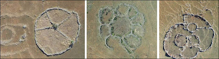
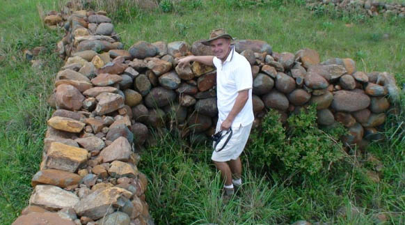
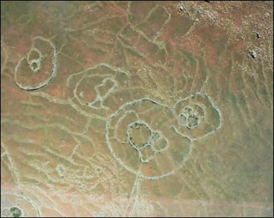 Over the past 20 years, people like Cyril Hromnik, Richard Wade, Johan Heine and a handful of others have discovered that these stone structures are not what the seem to be. In fact these are now believed to be the remains of ancient temples and astronomical observatories of lost ancient civilizations that stretch back for many thousands of years.
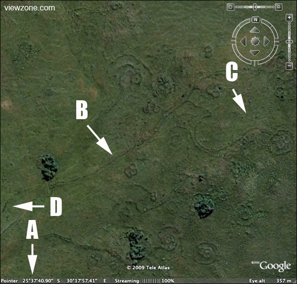
No comments:
Post a Comment